Fey
Nook Inc.’s Pet
Calling all Explorers:
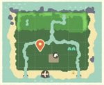
In the spirit of new discoveries, let’s take a closer look at E3s Island Map and see what possible conclusions we can draw from it!

The Obvious
✦ three beach sides
✦ one rocky side
✦ different levels of elevation
The Unknown
✦ What is the purpose of the thin green strip framing the top and sides of the upper level?
✦ What is the significance of the two visible gaps in this thin strip?
✦ What is the meaning of the four dark lines right below the foot of the mountains?
Is it all purely for aesthetics? Maybe just a coincidence, or even an error on the map? If not, might this be an area designated for future additions, such as shops and services? Are the lines indicators for four major buildings?
I’m curious to hear your thoughts and see if we can get closer to decrypting what they’ve mapped out for us so far!
In the spirit of new discoveries, let’s take a closer look at E3s Island Map and see what possible conclusions we can draw from it!

The Obvious
✦ three beach sides
✦ one rocky side
✦ different levels of elevation
The Unknown
✦ What is the purpose of the thin green strip framing the top and sides of the upper level?
✦ What is the significance of the two visible gaps in this thin strip?
✦ What is the meaning of the four dark lines right below the foot of the mountains?
Is it all purely for aesthetics? Maybe just a coincidence, or even an error on the map? If not, might this be an area designated for future additions, such as shops and services? Are the lines indicators for four major buildings?
I’m curious to hear your thoughts and see if we can get closer to decrypting what they’ve mapped out for us so far!
Last edited:

